On one side, polished glass towers catch the first light. On the other, the ocean presses silently against the barrier, a gray, heavy presence. The tide rises, slaps, retreats. Rises again.
Where there used to be a strip of marsh and scrubby grass, there is now a vertical drop. No crabs scuttling in the mud, no reeds bending in the wind, no messy tangle of life. Just engineered safety, measured in centimeters of projected sea-level rise and cost per meter of wall.
On paper, this is climate adaptation. In reality, it’s something more unsettling: cities quietly choosing which pieces of nature are allowed to stay, and which are sacrificed to the sea. The choice isn’t always where you’d expect.
The new shoreline: concrete first, nature if there’s room
Walk along almost any big-city harbor now and you feel it: the coast is hardening. Old wooden piers get replaced by steel and stone. Marshes become linear parks on top of buried seawalls. The language sounds gentle - “resilience,” “protection,” “waterfront renewal” - but the physical result is very blunt.
What used to be a soft, shifting boundary between land and sea is turning into a line. Straight, clean, engineered. Sea-level projections are fed into models, and an invisible threshold appears: here is where the wall must go, at this height, by this date. The map doesn’t show the fish nurseries that disappear when a marsh is boxed in. Or the birds that never land there again.
In New York, the $1.45 billion East Side Coastal Resiliency project raised a 2.4-mile stretch of Manhattan’s waterfront by several meters. Officially, it’s there to shield 110,000 residents from storm surges and rising tides. To do that, the city literally lifted the park, burying the old shoreline under tons of fill and concrete. One of the few pieces of nature left in that dense part of the city was dismantled, then rebuilt as something tidier, safer, more controlled.
Tokyo did something similar decades earlier, ringing much of its waterfront with sea walls and floodgates. Those defenses protected millions from disasters like Typhoon Hagibis in 2019. At the same time, they erased almost every remnant of the original tidal marshes that once cradled Tokyo Bay. These quiet, muddy edges never stood a chance against industrial land values and a city’s fear of flooding. The deal was never really up for public debate: safety first, wildness later - if at all.
Urban planners will tell you these projects are non-negotiable. Rising seas and stronger storms are already here; flood maps are brutally clear. You can’t just “let the water in” when you have hospitals, subways, and half a million apartments at stake. So cities do what they know how to do quickly: build walls, raise land, pour concrete. It’s fast, it’s legible in a budget, it photographs well at ribbon-cuttings.
What gets lost is less visible, slower, harder to value in dollars. Salt marshes that once absorbed storm energy. Oyster reefs that filtered water and softened waves. Mudflats that gave migratory birds a place to rest. These aren’t just pretty extras. They are a quiet infrastructure that took centuries to grow, now trapped behind a vertical edge where the sea has nowhere to spread but up.
When saving a city means sacrificing a shoreline
There’s a blunt tactic many coastal engineers use now: “triage.” When the numbers don’t add up, you decide what to save and what to let go. It sounds clinical because it is. Whole stretches of shoreline are being written off as too expensive to protect - or too valuable in real estate terms to leave natural. The decisions are rarely spelled out in plain language for residents.
In some European cities, less dense or less wealthy coastal neighborhoods are quietly moved into the “managed retreat” column. That means services are reduced, buyouts are offered, and nature is allowed to reclaim the edge. A few kilometers away, in a central business district, billions are poured into elevated promenades and armored embankments. Same ocean, different rights to stay dry.
A striking example is Jakarta, one of the fastest-sinking cities on Earth. Parts of the city are dropping by up to 25 centimeters a year due to groundwater extraction, while the Java Sea rises. Officials greenlit the “Giant Sea Wall” project - a vast barrier meant to shield the urban core. At the same time, dozens of informal settlements along the northern coast face eviction or flooding, with little chance of being included in the fortified zone.
In Louisiana, the story flips but the logic is similar. The state’s Coastal Master Plan maps areas where marshes will be “allowed” to drown as sea level rises, while sediment and money are concentrated in a few priority zones. Coastal communities on sinking land read those maps as a deadline on their existence. The levees and barriers protect oil infrastructure and cities like New Orleans; the wetlands and tiny fishing towns farther out are, in practice, treated as expendable buffers.
All of this exposes a quiet hierarchy of value. Not all nature is treated equally, and not all people living near that nature are, either. A patch of urban mangrove that protects a wealthy waterfront district suddenly gets attention, studies, creative “hybrid” solutions. An equally vital mangrove belt next to an industrial zone or low-income neighborhood is more likely to be flattened, filled, and replaced with a straight concrete line. The sea doesn’t care where the wall goes. The budget does.
This is where the climate crisis collides with politics and property. Once a city frames its coastline as a defense line, every meter becomes a choice: protect the tower, the highway, the port - or leave room for a living wetland that can wander inland as seas rise. Most of the time, the wetland loses. The language stays polite, but what’s happening is stark: nature is being zoned like real estate, sorted into “save,” “shrink,” and “sacrifice.”
Can walls and wetlands coexist on the same shoreline?
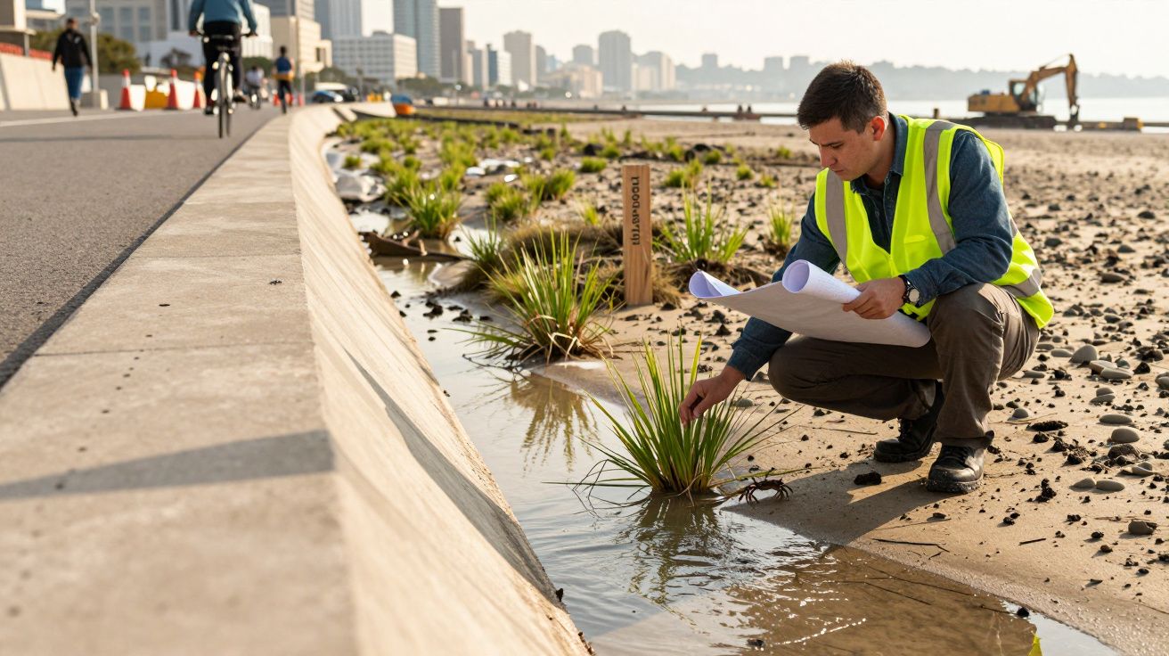
Some cities are trying something different: instead of a hard “no” between land and sea, they’re experimenting with layered defenses. Behind a modest wall or berm, they create space for salt marshes, oyster reefs, or mangroves to grow. The idea is simple: use concrete where you must, and living systems where you can. Let them share the job.
In Rotterdam, the Netherlands, planners talk about “room for the river.” Parts of the city are deliberately left lower, so floodwaters have a place to spread without wrecking homes. Green dikes blend slopes, plants, and hidden structures. They still control water, but they also host insects, birds, and weekend picnics. It’s not a romantic return to some wild past; it’s a practical mix of old instincts and new tools.
New York is testing similar ideas with “living shorelines” in Staten Island and along parts of the Hudson. Instead of a sheer wall, designers place terraces of rocks, plants, and salt-tolerant shrubs. Over time, they hope these edges trap sediment and soften storm surges, while giving fish and shellfish a foothold again. It’s a slow fix in a fast-moving crisis, but it starts from a different question: how do we defend ourselves without turning the shoreline into a lifeless curb?
The catch is that these hybrid solutions ask something cities rarely give easily: space. A living shoreline needs room to move as seas rise. A marsh must “migrate” inland, or it will be squeezed between a fixed wall and a rising tide - a problem scientists bluntly call “coastal squeeze.” That means saying no to some waterfront condos, rerouting a road, or redesigning a park to flood now and then. Let’s be honest: almost nobody does that every day.
People get nervous when you tell them their local park is designed to go underwater during storms. Yet when it works, the payoff is real. Floodwaters spread into a wetland basin instead of into basements. Insurance claims drop. Kids grow up seeing a coastline that still feels alive, not just protective. Engineers call it multi-benefit design; parents just call it a place where you can still hear frogs at night.
“Every meter of coastline is saying: choose. You can build higher walls, or you can build deeper relationships with the living systems beside you. The hardest part is admitting we can’t have everything, everywhere, forever.”
For anyone living near the water, a few simple lenses make these choices clearer:
- Look for who gets the strongest walls - and who gets “nature-based” projects.
- Notice where nature is allowed to move inland, and where it’s locked behind edges.
- Ask how flood risk is shared between business districts and residential streets.
- Watch how often local voices, not just experts, shape shoreline plans.
- Remember that an intact marsh or reef is not a luxury. It’s a form of insurance.
The quiet vote we cast with every new wall
We rarely think of a seawall as a moral choice. It looks like a technical fix: concrete, rebar, a neat line on a map. Yet each new barrier quietly redraws who belongs at the water’s edge - people, yes, but also birds, fish, grasses, entire webs of life that can’t file a planning objection. Once a city gets used to a hardened shoreline, it’s hard to imagine that line ever softening again.
On a hot evening in a coastal suburb, families gather on a new promenade built atop a storm barrier. Kids ride scooters, couples lean on railings taking selfies with the sunset. The wall has become a social space, a symbol of survival. Down below, the tide pushes against a blank surface, searching for the muddy in-between that used to be there. It never finds it. The loss is quiet, but constant.
We’ve all had that moment where a familiar place changes so slowly that you only really notice when someone shows you an old photo. The same is happening to our coasts. A clump of mangroves cut back “just a bit” for better views. A shallow bay dredged for deeper shipping lanes. A marsh pinned in behind a path “for safety.” Each step feels small. Put together, they tell a story: safety has been equated almost exclusively with height and hardness, not with diversity and flexibility.
As seas rise through this century, the pace of these decisions will only accelerate. Cities will be pitched grand visions of climate walls and surge barriers, glossy renderings where water becomes a controlled backdrop. The question isn’t whether we’ll protect ourselves. Of course we will try. The question is how many other forms of life we’re willing to evict in the process, and whether we’re brave enough to leave some coastlines soft, shifting, and shared.
| Key point | Detail | Why it matters to you |
|---|---|---|
| Hardening shorelines | Cities are enclosing coasts behind concrete walls, replacing marshes and mudflats with engineered edges. | Helps you recognize how everyday waterfront projects reshape risk, nature, and public space. |
| Unequal protection | Wealthy districts tend to get massive defenses, while vulnerable communities and ecosystems are pushed toward retreat. | Encourages you to question who benefits from climate adaptation - and who quietly pays the price. |
| Hybrid solutions | “Living shorelines” and layered defenses blend walls with wetlands, reefs, and green spaces. | Offers a way to imagine coastal cities that stay safe without turning the sea into a sterile, off-limits threat. |
FAQ
- Why are cities building so many concrete walls along the coast? Because sea levels and storm surges are rising, mayors and engineers reach for tools they trust: hard structures that offer clear, measurable protection for dense, expensive infrastructure.
- Do these seawalls really damage nature that much? Yes. Vertical, armored edges erase the shallow, messy transition zones where many species feed, breed, and seek shelter, and they can trap wetlands between the wall and the rising sea.
- What is a “living shoreline” in practice? It’s a coastal design that uses plants, rocks, reefs, and gentle slopes to absorb waves and reduce erosion, sometimes combined with smaller hidden walls or berms behind them.
- Are there cities that manage to protect both people and ecosystems? Places like Rotterdam, parts of New York, and some Australian and Asian cities are experimenting with hybrid defenses, floodable parks, and restored wetlands as part of their protection plans.
- What can residents actually do about these big coastal projects? They can show up at public hearings, support local groups pushing for nature-based options, ask who is protected first, and push for plans that leave room for wetlands, reefs, and public access.


Comments
No comments yet. Be the first to comment!
Leave a Comment